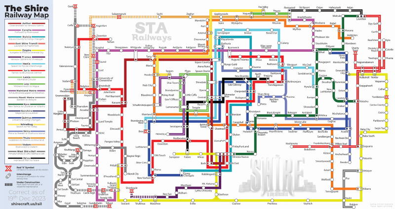
File:Shire Railway Map.png
From The Shire

Size of this preview: 800 × 424 pixels. Other resolution: 2,456 × 1,301 pixels.
Original file (2,456 × 1,301 pixels, file size: 500 KB, MIME type: image/png)
File history
Click on a date/time to view the file as it appeared at that time.
| Date/Time | Thumbnail | Dimensions | User | Comment | |
|---|---|---|---|---|---|
| 00:38, 5 February 2016 |  | 2,300 × 1,279 (192 KB) | Andy (talk | contribs) | ||
| 17:08, 2 January 2016 |  | 2,399 × 1,334 (215 KB) | Andy (talk | contribs) | added south-east proposed extension | |
| 00:12, 30 December 2015 |  | 2,345 × 1,304 (200 KB) | Andy (talk | contribs) | ||
| 02:59, 29 December 2015 |  | 2,300 × 1,279 (195 KB) | Andy (talk | contribs) | ||
| 02:00, 24 December 2015 |  | 2,100 × 1,168 (185 KB) | Andy (talk | contribs) | Updated north-east corner | |
| 22:43, 20 December 2015 |  | 2,468 × 1,372 (161 KB) | Andy (talk | contribs) | ||
| 03:25, 27 October 2015 |  | 2,579 × 1,434 (229 KB) | Andy (talk | contribs) | Line extensions | |
| 01:17, 14 August 2015 |  | 2,344 × 1,257 (233 KB) | Andy (talk | contribs) | ||
| 00:17, 5 August 2015 |  | 2,345 × 1,258 (213 KB) | Andy (talk | contribs) | Empire line updated | |
| 22:36, 2 August 2015 |  | 2,001 × 1,073 (176 KB) | Andy (talk | contribs) |
You cannot overwrite this file.
File usage
The following 2 pages use this file:
- Railways
- File:Shire Railway Map 2018.png (file redirect)